|
|
FRINGE 96 |
|
||||||
|
|
||||||||
| M. S. Seymour and I. G. Cumming |
Radar Remote Sensing Group, Dept. of Electrical Engineering, The University of British Columbia, 2356 Main Mall, Vancouver, BC, Canada V6T 1Z4. seymour@ee.ubc.ca http://www.ee.ubc.ca/sar/group.html |
|
Keywords: SAR interferometry, baseline estimation, topography
The need for accurate baseline estimation in satellite SAR interferometry is especially acute if we wish to make use of an existing DEM. We have developed an algorithm which produces accurate results using an existing DEM and which is amenable to automation. The algorithm and a processing example are described below.
The UBC Radar Remote Sensing Group (RRSG) has a complete system for SAR and InSAR processing. A quick look processor using the SPECAN algorithm was implemented in IDL. This provides the group with a medium resolution product sufficient for locating areas of interest for further processing and checking the data quality and conditions. dtSAR is the group's primary vehicle for producing full resolution SAR images. This processor is a modified port of the well-known VMP processor installed on a Sun Sparc-10 workstation. It has been extended to provide the chirp scaling algorithm as well as the usual range/Doppler algorithm. dtSAR provides phase preserving processing so the single look complex (SLC) imagery it produces is suitable for InSAR processing. A suite of 'C' programs have been developed for all the stages of InSAR processing. A graphical user interface (GUI) was built to provide the user with an easy interface to the 'C' program suite. Currently, a second generation InSAR processor is being developed using MATLAB which initially requires no input from the user other than the area of the image to process.
Many areas of the world either already have existing DEM coverage or will have after the Shuttle Radar Topography Mapping (SRTM) mission. Although the primary initial purpose of InSAR was topographic estimation, other applications of the technology including differential topography estimation and classification via coherence magnitude are also of interest. Two fundamental parameters of InSAR are the baseline orientation and length which control the mapping from topography to interferogram phase. Manual accurate methods or automatic approximate methods exist [Massonnet et al., Prati et al., Small et al.] for estimating the baseline magnitude and orientation for satellite InSAR. Even with precision orbit data, refinement of the baseline estimates is required.
It would be useful to include any existing DEM data in the InSAR data processing algorithm. Clearly, to relate existing DEM data to an interferogram it is necessary to know the baseline magnitude and orientation accurately. We have developed an algorithm which will estimate the interferometer geometry given an overlapping DEM. The algorithm proceeds in two stages:
The registration of the interferogram and the DEM is a necessary stage in the algorithm. In general, SAR images are collected in slant range and azimuth coordinates with no particular relation to an external coordinate system. DEM's are usually presented in UTM coordinates and may be either gridded or have scattered data positions. Precision or restituted orbit data can be used to generate a gridded estimate of the unwrapped interferogram phase. This can be correlated with the interferogram to estimate the precise resampling relation to map the DEM to slant range coordinates. This is equivalent to geocoding the SAR data and is useful information in itself.
Once the DEM and interferogram are registered, an accurate estimate of the interferometer geometry can be made. We have developed an iterative method which makes use of the registration relation between the two SAR images used to make the interferogram. The method is based on minimizing the sum of squared differences between the estimate of the fitted second slant range and the estimate using the geometry and the co-located DEM. For satellite SAR systems, registration can be done with a linear stretch in range and a range dependent linear shift in azimuth. There is not enough information in the registration relation to guarantee that a good estimate of the interferometer geometry will be generated. In general, if the registration relation alone is used, there will be phase ramps in range and azimuth corresponding to errors in the estimated baseline magnitude and orientation. However, we use this residual phase to correct the registration relation to get a very accurate fit to the updated registration parameters. The result is an algorithm that is exact to within the stopping criterion for the iteration and the error of the supplied DEM.
Note that this algorithm does not depend on comparing terrain heights between the interferogram and the DEM and that the algorithm does not use phase unwrapping. These are useful properties because the algorithm could conceivably be run without external intervention. Work is ongoing to check the algorithm's performance in the presence of DEM errors and to automate our implementation of it.
The full iterative algorithm including residual phase processing was applied to a set of Tandem Mission data. The data processed for this paper consist of an ERS-1 SAR image (orbit 21730) and a co-located ERS-2 SAR image (orbit 2057) collected on September 10, 1995 and September 11, 1995 respectively at a local time of approximately 10 AM PST. The SAR data was collected on track 199 at frame 2565 for both satellites. The center of the scene is 51o 35' 20" N, 121o 59' 20" W. Weather records for the region indicate that the weather had been stable for about 4 days previous to the first data collection with the diurnal cycle of warming to about 23oC during the day and falling to 2-3oC during the night. The stable weather conditions are positive indicators for good correlation between the SAR images used to create the interferogram. From the ERS-1 InSAR baseline listing [Solaas], the baseline is estimated to be -45 meters, well within desirable limits on the normal baseline for SAR interferometry. The preliminary smoothed phase of the interferogram for a subset of the data is shown below.

In addition, the Chilcotin area has extensive coverage by 1:10,000 digital map sheets called Terrain Resource Information Maps [Surveys and Resource Mapping Branch]. These maps are publicly available digital mapping products generated by the Surveys and Resource Mapping Branch of the government of British Columbia. The following specifications are most relevant to interferometric SAR processing:
The discrete spot height elevations of the TRIM DEM file were extracted and processed to provide uniform terrain heights in slant range and azimuth coordinates using precision orbit data for a subset of the data. The iterative baseline estimation algorithm was applied to generate the following estimate of the ERS 1/2 interferogram based on the DEM data.
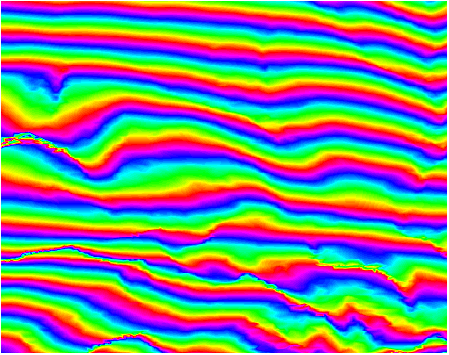
The residual interferogram calculated as the phase of the "differential interferogram" between the estimated and fitted interferogram is shown below. There is reasonable agreement between the the synthetic and ERS 1/2 interferograms. It is interesting to note the amount of details present in the residual interferogram. The small linear features correspond to terrain features (mostly drainage channels) that are not present in the TRIM resource map. Presumably, the size of the features is less than the minimum 75 meter sample spacing. This demonstrates the possibility of using SAR interferometry to update and add detail to existing DEM maps. The two wider bright linear features at the left of the image are due to the effects of uncorrected layover in the slant range mapping used to derive the synthetic interferogram. The diffuse brighter and darker patterns may be due to vegetation cover or atmospheric effects.
![]()
Residual Interferogram - phase difference between interferogram data and estimated interferogram derived using iterative algorithm and DEM data.
An iterative algorithm for estimating the baseline magnitude and orientation in SAR interferometry has been reviewed. Processing results for a sample data set were shown. There was good correspondence between the fitted interferogram estimated from the accurate TRIM data and the corresponding ERS 1/2 interferogram which implies an accurate estimate of the baseline magnitude and orientation. Furthermore, subtle details in the topography which are missed during the DEM generation process because of the sampling rate of the raw data capture are clearly visible in the residual interferogram. Thus, the possibility of updating DEMs using overlapping interferometric SAR data seems possible. Future work includes fully automating the algorithm and testing the algorithm's performance on marginal quality DEM data.
The authors wish to thank the European Space Agency for providing the ERS-1/2 data as part of the Tandem Mission Announcement of Opportunity and Roger Balser of the Surveys and Resource Mapping Branch of the Province of BC for providing the TRIM data used in the paper. The authors also wish to thank the Natural Sciences and Engineering Research Council, MacDonald Dettwiler, the BC Advanced Systems Institute (ASI) and the BC Science Council for their financial support during the course of this research work.
(Conference
Program) ![]() (Participants)
(Participants)
![]() (Abstracts
and Papers)
(Abstracts
and Papers)
![]() (Contacts)
(Contacts)