|
|
FRINGE 96 |
|
|
|
|
|||
| Ian Cumming and Juan-Luis Valero |
Radar Remote Sensing Group, Dept. of Electrical Engineering, The University of British Columbia, 2356 Main Mall, Vancouver, BC, Canada V6T 1Z4. E-mail address: ianc@ee.ubc.ca http://www.ee.ubc.ca/sar/ | |
|
Paris Vachon, Karim Mattar, Dirk Geudtner and Laurence Gray |
Canada Centre for Remote Sensing, 588 Booth Street, Ottawa, Ontario, Canada K1A 0Y7 E-mail address: vachon@ccrs.emr.ca http://www.ccrs.nrcan.gc.ca/ | |
Glacier measurements are important for hydrological studies, but are difficult to measure from the ground. We show that dense, wide-area flow measurements can be made from ERS Tandem Mission data, as long as the surface of the glacier is stable. The necessary stability conditions occur when the temperature is below freezing and no precipitation or strong winds occur during the observation interval.
Differential interferometry requires that the phase due to topography be removed from the phase due to motion in the interferogram. We do this by using an accurate DEM obtained from the CCRS Convair-580 across-track interferometer and the ERS satellite geometry to derive the phase due to the topography. When this phase is subtracted, the motion fringes can be processed to obtain line-of-sight glacier flow. Then, by assuming a given glacier flow direction, the LOS motion can be projected to the proper flow direction.
We show results obtained from the Saskatchewan Glacier on November 2/3 1995. The measured flows range up to 30 cm/day. They have been verified to be accurate to within 10% by ground measurements, and later SAR observations taken in November 1995, March 1996 and April 1996 reveal that the fine-scale structure of the glacier flow patterns are very repeatable.
Keywords: Differential interferometry, Glacier flow measurements
Go to Table of Contents of this paper.
2. Current Glacier Measurements
4. InSAR Processing
4.1 Processing the Glacier Interferogram
4.2 The Convair-580 DEM
4.3 Removing Topo Phase from the Interferogram
5. Glacier Flow Measurements
5.1 InSAR Flow Measurements
5.2 Ground Truth
5.3 Discussion
or scroll down for body of paper.
In this paper, we show how differential interferometry from the ERS satellites operating in Tandem Mode can yield excellent measurements of the flow rates of alpine glaciers. As long as the surface conditions are stable during the observation interval, accuracies of a few cm/day can be obtained from the ERS data.
In the interferometric processing, a means must be available to separate the phase differences in the interferogram due to topography from those due to motion. In this work, we use a DEM and a model of the satellite geometry to subtract the topographic phase, leaving a clear picture of glacier surface motion.
Our main results are taken over the Saskatchewan Glacier in western Canada in November 1995. We show the topographically-corrected interferogram, and the velocity map derived from it.
Glaciers have been studied for a long time, including measuring their area, depth, accumulation, water runoff, snow line position and terminus extent [Paterson, 1994]. They are an important indicator of historical and present global climate, as their parameters are an integral of climate and environmental effects such as temperature, precipitation and pollution. By taking core samples and dimensional measurements, glaciologists can infer climate and make models of glacier dynamics. Now that water resources are in scarce supply in many parts of the world, it is all the more important to make accurate measurements and models of glacier mass balance to forecast the water available for future consumption and to predict floods and droughts.
Measurements have traditionally be made on glaciers by ground-based crews, and sometimes by helicopters. These measurements are difficult and expensive to make, with the result that few glaciers are monitored, and even then, only a sparse set of readings can be taken. Many glaciers are relatively inaccessible and weather conditions often prevent operation by field crews.
We will focus our attention on the Saskatchewan Glacier, located at 52o 8' N, 117o 11' W. It is the largest glacier in the Columbia Icefield, and has a favourable orientation for imaging with ERS ascending passes. The descending pass view direction is also reasonably good. A 1:50,000 topographic map of the glacier is shown in Figure 1. The Columbia Icefield can be seen on the left side of the map, and the tongue of the glacier can be seen flowing from west to east across the map. The tongue is approximately 10 Km long and 1 Km wide.
Repeat-pass satellite InSAR processing of the 1-day repeat ERS Tandem Mission data was done at CCRS [Vachon et al., 1996a] and at UBC [Cumming et al., 1996]. The data was taken from the ascending pass frame 1035. The first data processed was from ERS-1 orbit 22481 on November 2, 1995 and ERS-2 orbit 2808 on November 3, 1995. The data was processed into SLC images with the MacDonald Dettwiler dtSAR processor, registered and an interferogram formed.
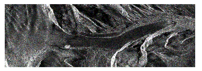
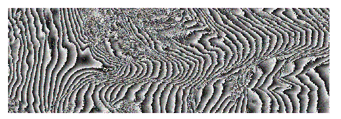
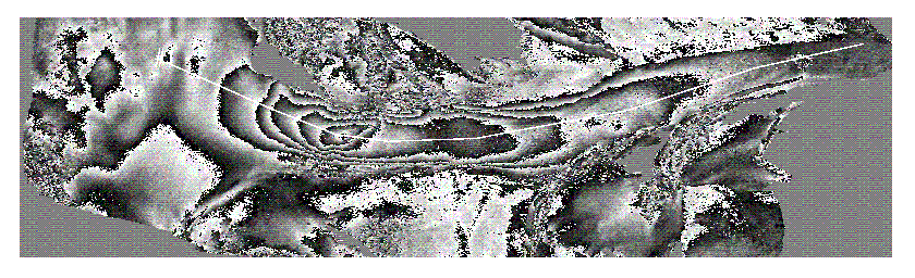
The magnitude and phase of the interferogram is given in Figure 2 and Figure 3 respectively, showing a 16 Km (range) by 5 Km (azimuth) portion of the scene. The left hand 1/5 of the scene shows the Columbia Icefield, which is the accumulation area of the glacier.The 10 Km long tongue of the Saskatchewan Glacier runs from left to right through the middle of the scene, ending in a terminal moraine at the right of the image. Note than the SAR images are rotated about 12o with respect to the map, as they are displayed in the slant range alignment given by the ERS ascending pass viewing direction.
The interferogram shows reasonably good coherence on the ice surface (average coherence about 0.8). The areas where the phase noise is high are mountainous areas above and below the glacier, where layover is significant.
In the interferogram, the differential phase is due to:
As we are interested in extracting glacier motion, the topography phase must be removed from the interferogram. This can be done in at least two ways:
The first approach has been used successfully on the Greenland Ice Sheet [Joughin et al., 1996, Kwok and Fahnestock, 1996]. This method is not useful for Tandem Mission data, as the required 3 data takes are separated by at least 35 days, which is too long to obtain coherence over a glacier surface. In our case, an accurate DEM has been obtained by the CCRS Convair-580, and will be used with the second approach.
The Convair-580 SAR was flown over the test area in March and August 1995, with a viewing direction from the north-east (looking up the glacier). Figure 4 shows a SAR image taken from the March flight. The area shown is a little larger than the satellite image of Figure 2. Compared to the ERS images, the Convair image has a higher resolution, larger incidence angle and a higher SNR.
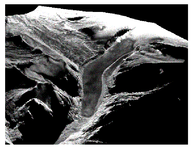
The Convair cross-track interferometric data [Gray et al., 1995] was processed to a 5 meter posting DEM by CCRS [Mattar et al., 1995], using both the March and August data. The two DEMs agreed to within 5 meters in most areas. The DEM is more accurate than would be obtained from a satellite InSAR because of the high SNR and resolution, and because the two interferometric channels are collected simultaneously. The final DEM was produced in UTM coordinates, and for illustration purposes was used to create a perspective view of the SAR image, as shown in Figure 5.
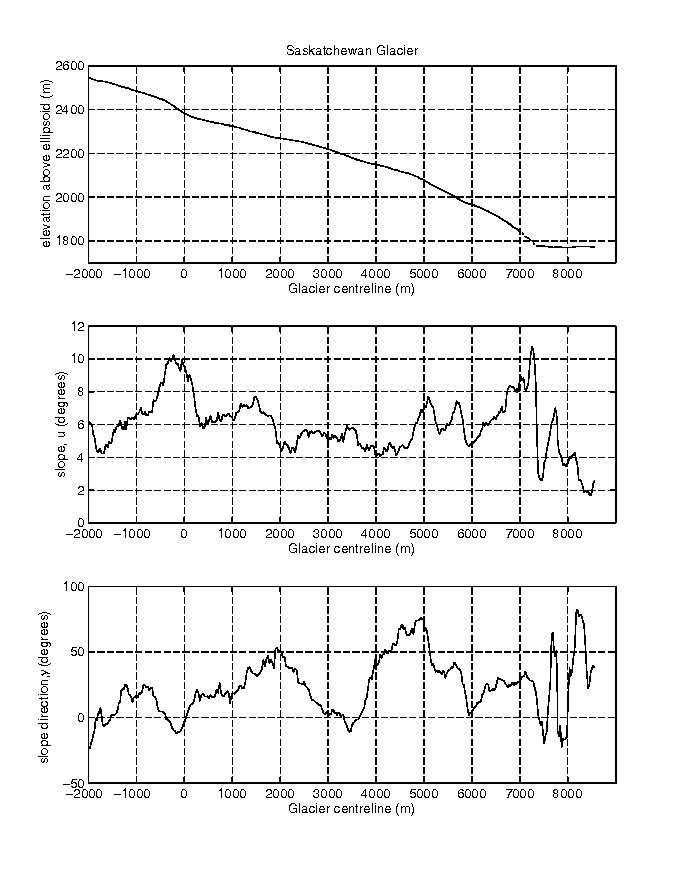
The DEM is mainly used to remove the topographic phase from the ERS interferogram. However, other parameters can be extracted from the DEM, such as the surface height, the surface slope, u, and the direction of maximum slope, v, which are subsequently used to define the assumed glacier flow direction along which the ERS measured displacement will be projected. These parameters are measured along the centreline of the glacier, and are shown in Figure 6.
The Convair-580 DEM was resampled to the ERS slant range/azimuth grid, and used to compute the topographic phase that would be expected with the 94 meter baseline. The result is shown in Figure 7, where fringes due to the change in line-of-sight velocity are clearly seen. Most of the rocky areas adjacent to the glacier have the same phase, which can be assigned a zero motion value. Because the baseline is relatively small, the sensitivity of phase to errors in the DEM and in the satellite geometry is quite low.
In this section, we extract the glacier flow from the ERS SAR data, and compare it to flow measurements taken from surface readings.
A 200 meter strip of the ERS SAR data was chosen around the glacier centerline (the white line in Figure 7). The phase was smoothed in this region, then unwrapped. As each phase fringe represents 2.85 cm of motion parallel to the radar beam vector over the 1-day interval, a curve of line-of-sight (LOS) displacement could be plotted vs. the distance along the centreline.
However, our interest lies in measuring the surface velocity, so we must determine what surface velocity creates the measured LOS velocity. To do this, we make the assumption that the surface flow is parallel to the surface, in the direction of the maximum slope. Then, using a reverse projection, the LOS displacement values are converted into surface displacements.
To date, five Tandem Mission data pairs taken between November 1995 and April 1996 have been analyzed in this fashion, and the surface displacements in cm/day are plotted in Figure 8. Six other Tandem Mission data pairs taken during this interval had too low a coherence to give useful results [Vachon et al., 1996b].
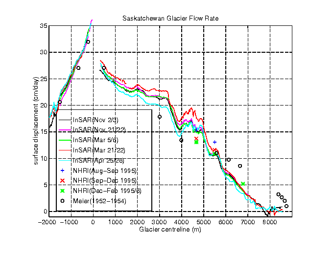
Also shown in Figure 8 are measurements taken by Meier in the 1950s [Meier, 1960]. They cover a larger area of the glacier than the NHRI measurements, and are the average over a whole year of observations. Meier's measurements to the right of 6000 m in Figure 8 are not relevant today, as the terminus of the glacier has receeded by about a kilometer since that time. Both Meier's and the NHRI measurements included 3-dimensional displacement measurements, and confirmed that our assumption of flow direction was accurate to within a few degrees.
Weather readings logged every hour confirmed that the temperatures were always below freezing and no precipitation occurred on the 5 days that the high-coherence InSAR measurements were taken. Typical temperatures of the air and of the ice were between -1oC and -10oC for these 5 days [Vachon et al., 1996b].
First note that there is a remarkable consistency between the 5 sets of SAR measurements, as their fine-scale structure is almost the same. This consistency leads us to believe that the SAR measurements before projection are accurate to 1-3 cm/day, but some of the similarity of the fine-scale structure comes from the fact that the same projection direction was used in each of the 5 cases.
Second note that the agreement between the SAR and the ground measurements is very good -- in the order of 2-5 cm/day.
The velocity peak noted between -800 and 300 meters in Figure 8 is clearly related to the increase in surface slope seen in Figure 6. Presumably, the basal slope also increases in this area. However, the smaller changes in velocity noted between 3000 and 5000 meters in Figure 8 do not seem to be well correlated with the surface slope changes of Figure 6 (the detailed basal slopes are not available). At the present time, additional readings from the summer and fall of 1996 are being analyzed, and glaciological studies are underway to understand the physics behind the observed flow patterns.
There are a number of errors in the SAR and the ground measurements, and in how they are compared. Examples of the errors are:
We cannot accurately quantify all these errors, but given the uncertainty caused by each of them, we are pleasantly surprised by the agreement between the SAR and ground readings.
We have obtained glacier surface motion measurements using differential interferometry analysis of ERS Tandem Mission data over an alpine glacier in the Canadian Rocky Mountains. The 5 sets of SAR measurements show a remarkable consistency with each other, and there is good agreement with several sets of ground measurements taken around the same time.
Compared to the limited measurements taken by a ground survey crew, the SAR measurements cover the whole glacier surface (with roughly a 30 meter spacing), and can be obtained with modest incremental cost whenever the surface of the glacier is stable. Our limited experience suggest that winter conditions provide the best SAR observation conditions.
From this we can conclude that differential SAR interferometry is a useful tool for monitoring the surface motion of alpine glaciers. We hope that glaciologists can make good use of this new instrument, and that it will improve the accuracy of their glacier modeling work.
The authors would like thank Dr. Mindy Brugman and her crew for taking the surface measurements on the glacier. The authors are also grateful to Mike Seymour of UBC's Radar Remote Sensing Group for providing the programs and advice for the UBC segment of the interferometric processing, and for presentling the paper in Zurich.
We are very grateful to ESA for providing high-quality ERS data, and to CCRS for their prompt transcription service.
Funding for the UBC portion of the work was provided by CCRS and the NSERC/MDA Industrial Research Chair in Radar Remote Sensing.
(Conference Program)
![]() (Participants)
(Participants)
![]() (Abstracts and Papers)
(Abstracts and Papers)
![]() (Contacts)
(Contacts)